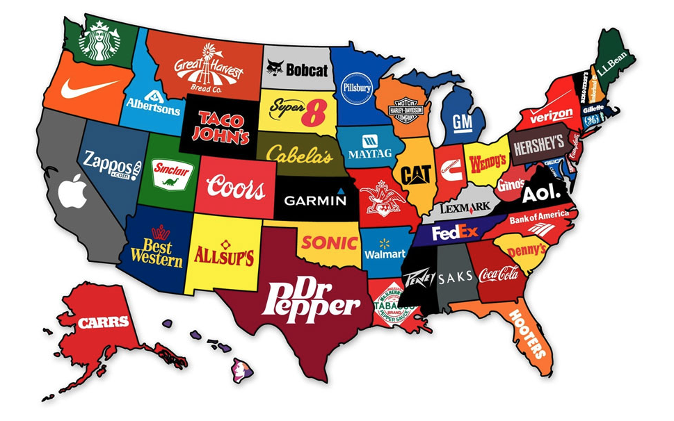
You all seem to enjoy these map posts as much as I do.
Every time we share one, I wind up hearing from readers who spend far longer looking at the maps than they planned. (Ask me how I know…)
So here’s another collection of maps that reveal interesting—and sometimes downright bizarre—facts about the good ol’ U.S. of A.
Some are educational. Some are nostalgic. A couple made me laugh out loud.
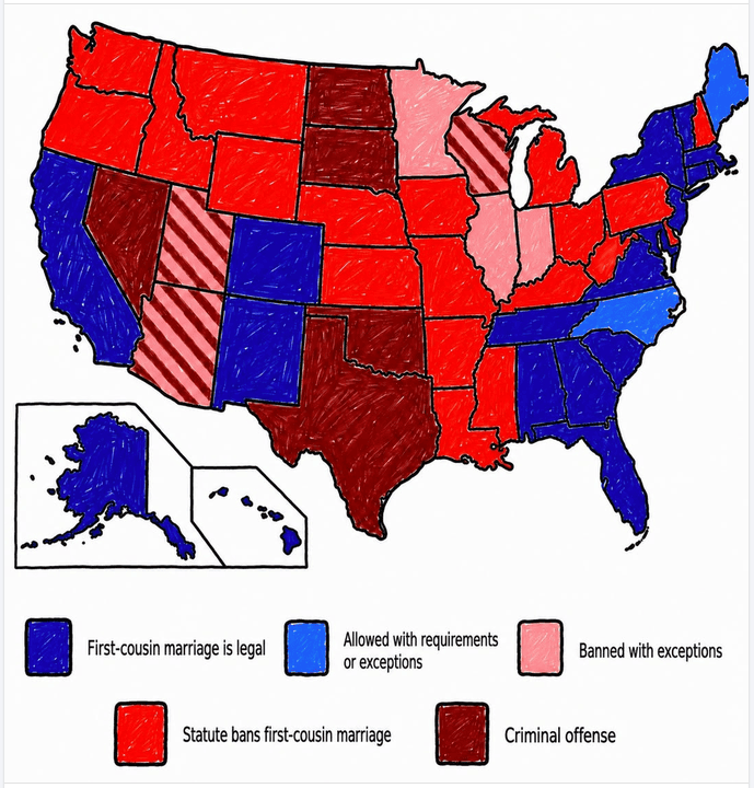
And yes…one of them shows where you can legally marry your first cousin.
Don’t blame me. I didn’t make the maps. 😄
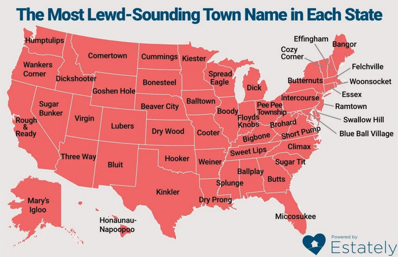
The most lewd-sounding town name in each state
Remember the town that was named with the mother of all curse words and it changed its name? Or the brothers who did an epic “rude trip” of all the towns in the UK that sounded the dirtiest? Good times.
Turns out that the U.S. has its own share of towns that have very adult names. Estately made a list of them. Take a look:
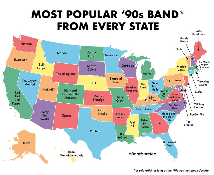
Most popular 90s band from every state
Matt Shirley, a.k.a. Matt Surelee, is well known for his charts, graphs, and diagrams about everyday life experiences. He has over 400k Instagram followers and has even written a book with examples of his unusual outlook on life, so he must be doing something right.
His charts and graphs are typically amusing, but I especially like when he focuses on a little-known aspect of the U.S. Case in point, the most popular 90s band from every state:
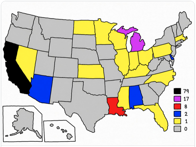
Number of times each state or city has been referenced in a Red Hot Chili Peppers lyric
And speaking of a group that was popular in the 90s…here are the number of times each state or city has been referenced in a Red Hot Chili Peppers lyric:
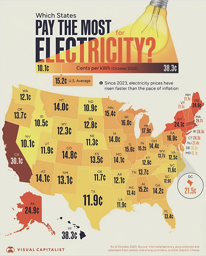
The states that pay the most for electricity
Utility bills have become a whole lot more painful over the past few years. In fact, the price for electricity has been skyrocketing faster than inflation since 2023. Visual Capitalist was able to map out which states pay the most for electricity (as of October 2025):
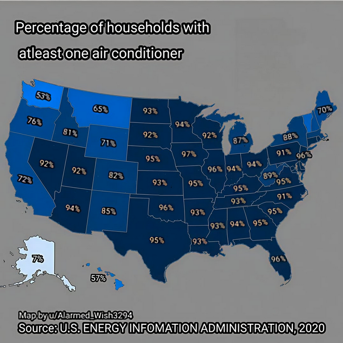
Percentage of households with at least one air conditioner
Of course, electricity costs go through the roof during the summer, thanks to air conditioning. Here’s a map that has the percentage of households with at least one air conditioner (note: the map was designed on information from 2020, so it may not be 100% accurate at this time).
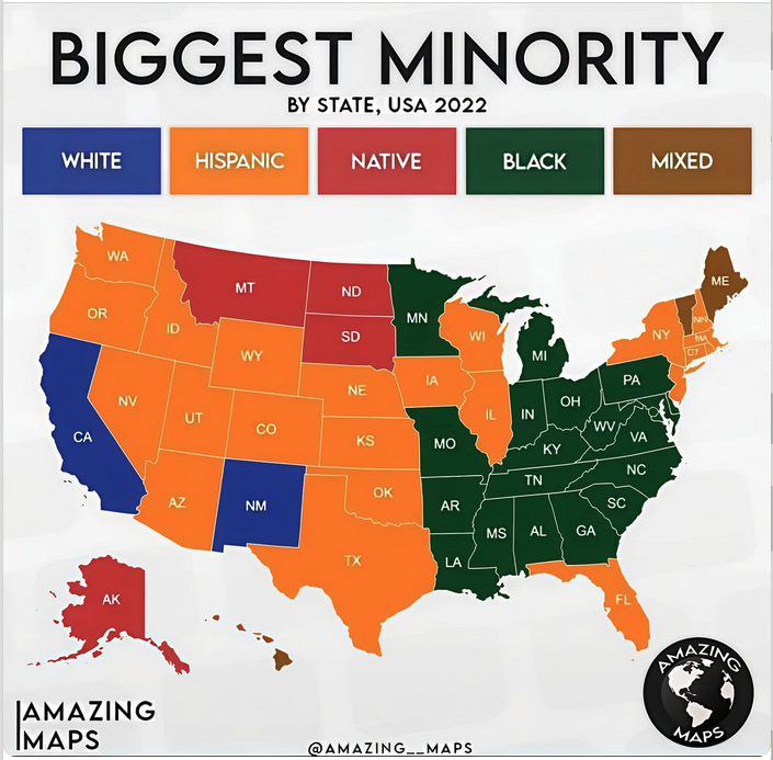
Biggest minority
People who pay attention to demographics say that it won’t be very many years until white people will be the minority in most of the U.S. In fact, that’s already the case in California and New Mexico. However, our friends at Amazing Maps did the research and discovered what the largest minority currently is in each state (granted, as of 2022).
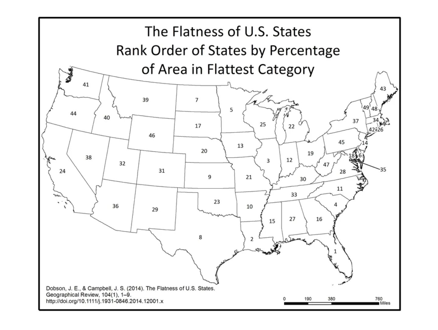
The flatness of U.S. states, ranked
The U.S., besides being a patchwork of people, is also so large that the topography of different states vary quite a bit. This map ranks 48 of the 50 states in order of flatness.
I don’t know why they didn’t include Alaska and Hawaii on the map. Thanks to Denali, Alaska, of course, would be #50. Hawaii’s nowhere to be found in the ranking. If anyone knows why, let me know because I couldn’t figure it out. I think they included Washington D.C. instead.
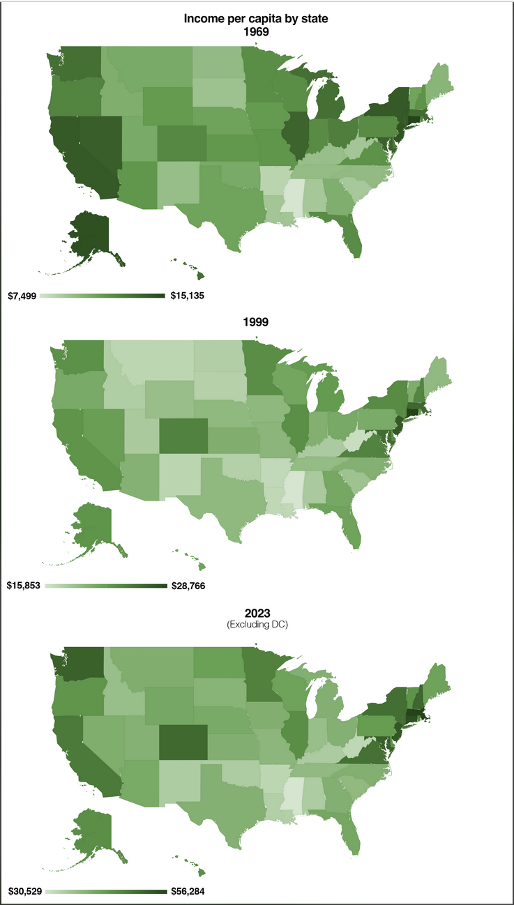
Income per capita
Americans’ income also varies depending on where they live. This map is interesting because it shows the progressing from 1969 through 2023. Yet even with some changes here and there through the years, the overall pattern remains surprisingly consistent—most states that were lighter colored (indicating lower income) remain lighter, and those that were darker (indicating higher income) remain darker.
Where you can legally marry your first cousin
I have no idea where they got this information from…but there ya go.
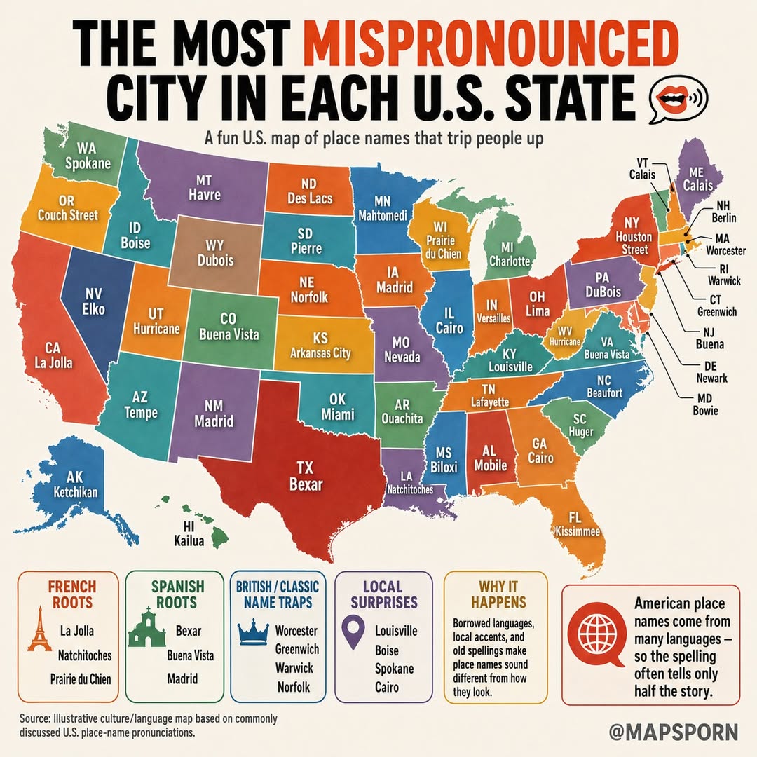
The most mispronounced city in each U.S. state
HOW-ston Street vs. HEW-ston Street. Kuh-SIM-ee vs. KISS-a-mee vs. the occasional KISS-mee. And I’m not even going to TRY “Natchitoches.” Here’s the most mispronounced city in each U.S. state, courtesy of our friends at Mapsporn.
See? I told you these were rabbit holes.
I always start out thinking I’ll spend a couple of minutes looking at one map, and before I know it I’m comparing my state to everyone else’s, zooming in on neighboring states and wondering who comes up with this stuff in the first place.
That’s probably why I like these collections so much. They’re informative, a little quirky and just plain fun to explore.
Which one was your favorite?
Or better yet…have you stumbled across a great U.S. map lately that deserves to be added to the next installment?
Feature photo: The most famous brands from each state in the U.S.
Want to comment on this post? Great! Read this first to help ensure it gets approved.
Want to sponsor a post, write something for Your Mileage May Vary or put ads on our site? Click here for more info.
Like this post? Please share it! We have plenty more just like it and would love it if you decided to hang around and sign up to get emailed notifications of when we post.
Whether you’ve read our articles before or this is the first time you’re stopping by, we’re really glad you’re here and hope you come back to visit again!
This post first appeared on Your Mileage May Vary