When you travel, you always need to be aware of emergency situations. We’ve gone over what to do if you’re out of town (or are planning to be out of town) and there’s a hurricane headed your way. But you never know when a hotel fire, terrorist situation, or natural disaster may strike right where you are.
Local and federal governments in the US want to be able to give people the information they’ll need during an emergency situation. They’ve set up emergency alerts that can be played on TVs, radios and phones during an emergency. To ensure this system works, they coordinate testing these alert systems here and there. In fact, today at 2:20pm ET, there will be a nationwide emergency alert test on cell phones, wireless devices, radios and TVs
IMPORTANT: On Wednesday, Oct. 4th at 2:20 p.m. ET, there will be a nationwide emergency alert test on cell phones, wireless devices, radios, and TVs.
This is a standard test that occurs at least once every three years. No action is needed.
Info & FAQs: https://t.co/KKyrIr4e03 pic.twitter.com/xDW92DwcAy
— FEMA (@fema) October 2, 2023
Coordinating these emergency alerts is a smart idea and I hope, if there ever was such an issue, that they’d work. However, as a tangent, I recently found a map that shows all the current emergency and disaster situations currently happening around the world.
Now, if you’ve been reading our blog for a while, you know that I love oddball maps. I’ve written about many of them in the past:
- The funniest map of Disney World I’ve ever seen
- Map shows where you’d be if you dug a hole straight through earth
- 15 maps that will blow your mind
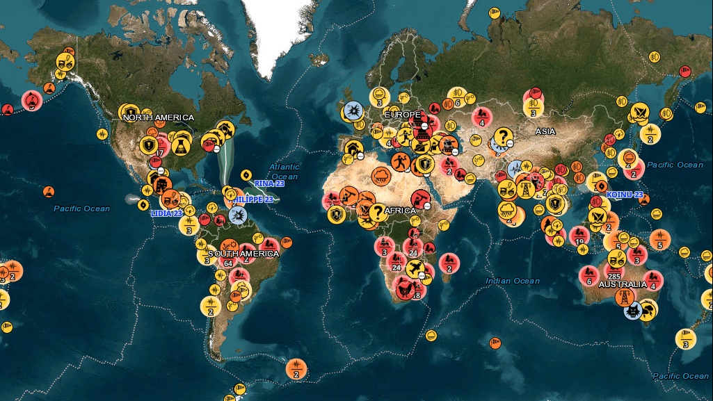
But this map isn’t meant to be quirky or funny. It’s made by the Hungarian National Association of Radio Distress-Signalling and Infocommunications (RSOE). They operate this map, called the Emergency and Disaster Information Service (EDIS) with the objective to monitor, document and analyze all kind of emergency or disaster events worldwide.
“We process data of several organizations, authorities and trusted media to obtain reliable information using the speed and the data spectrum of the internet. Our services include the displaying of gathered information on various user interfaces and the notification of customers on selected events.”
This is the entire map at once:
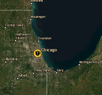
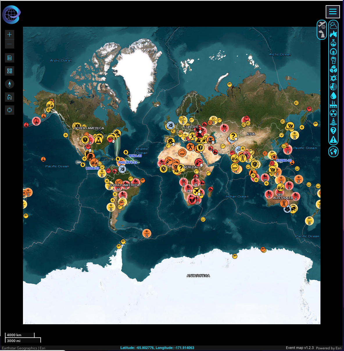 But you’re easily able to zoom in to see what’s going on in, let’s say, the Chicago area:
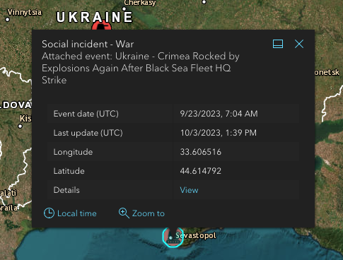
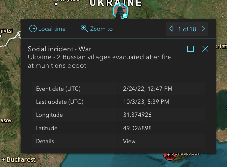
And if you click on that event, you get some of the details:
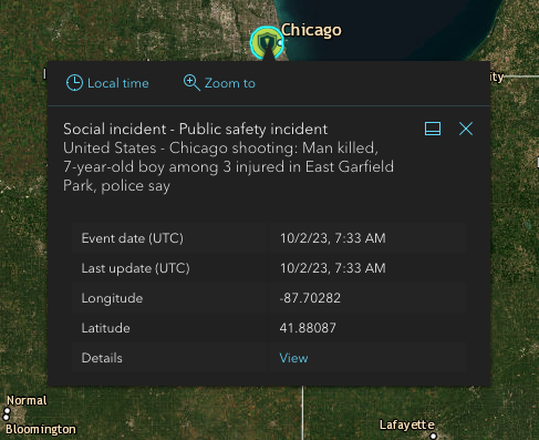 Want more details? Click on VIEW and learn much more about the emergency situation.
From https://rsoe-edis.org/eventList/details/484071/0:
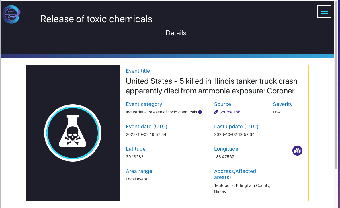 Exposure to anhydrous ammonia apparently caused the deaths of five people, including two children, when a tanker truck loaded with the hazardous material overturned on a highway Friday night in a rural Illinois community, according to preliminary findings from the local coroner’s office. At least seven other people from six different states were also treated at hospitals after being overcome by what authorities described as a “large plume cloud” that was released when the tanker truck spilled its load on a highway east of Teutopolis, Illinois, Effingham County Coroner Kim Rhodes said in a statement Sunday evening. Autopsies are scheduled to be performed Monday morning on the victims to confirm the preliminary findings, Rhodes said. “Preliminary investigation indicates five individuals died from exposure to anhydrous ammonia at the crash site,” according to Rhodes’ statement. Three of the people killed were from the same family. Those killed were identified by the coroner’s office as 34-year-old Kenneth Bryan of Teutopolis and his two children, 7-year-old Rosie Bryan and 10-year-old Walker Bryan, both of Beecher City, Illinois. Danny J. Smith, 67, of New Haven, Missouri, and Vasile Crivovan, 31, of Twinsburg, Ohio, also apparently succumbed to exposure to the anhydrous ammonia, according to the coroner’s preliminary investigation. The deadly highway wreck unfolded around 8:40 p.m. local time Friday when the semi-truck rolled over on U.S. Route 40 and spilled about 4,000 gallons of anhydrous ammonia on the roadway, causing “terribly dangerous air conditions,” Effingham County Sheriff Paul Kuhns told reporters on Saturday. Anhydrous ammonia is a clear, colorless gas that is toxic. Effects of inhalation range from nausea to respiratory tract irritation, depending on the length of exposure, according to the Centers for Disease Control and Prevention. The chemical is primarily used in farming as a nitrogen fertilizer. Rhodes said the victims were exposed to the ammonia “due to traveling through the scene of the crash site.” Seven people, including four teenagers, were treated at area hospitals for exposure to the anhydrous ammonia, including two who were admitted to hospitals, according to the coroner’s statement. About 500 residents living within roughly 2 square miles of the crash site were initially evacuated, authorities said. They were allowed to return to their homes on Saturday after the danger from the ammonia spill dissipated, Teutopolis Assistant Fire Chief Joe Holomy said in a statement. The cause of the crash remains under investigation. The National Transportation Safety Board, in coordination with the Illinois State Police and the Effingham County Sheriff’s Department, sent a 15-person team to conduct a safety investigation into the rollover crash, the agency said Saturday. Representatives from the U.S. Environmental Protection Agency also responded to the scene. Teutopolis is a small village in Effingham County, located about 92 miles southeast of Springfield, the capital of Illinois.
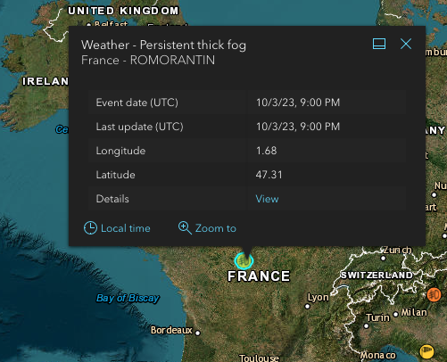
Some of the information may not be a “life or death” emergency, but still interesting and important to know. Such as “persistent thick fog” in France.
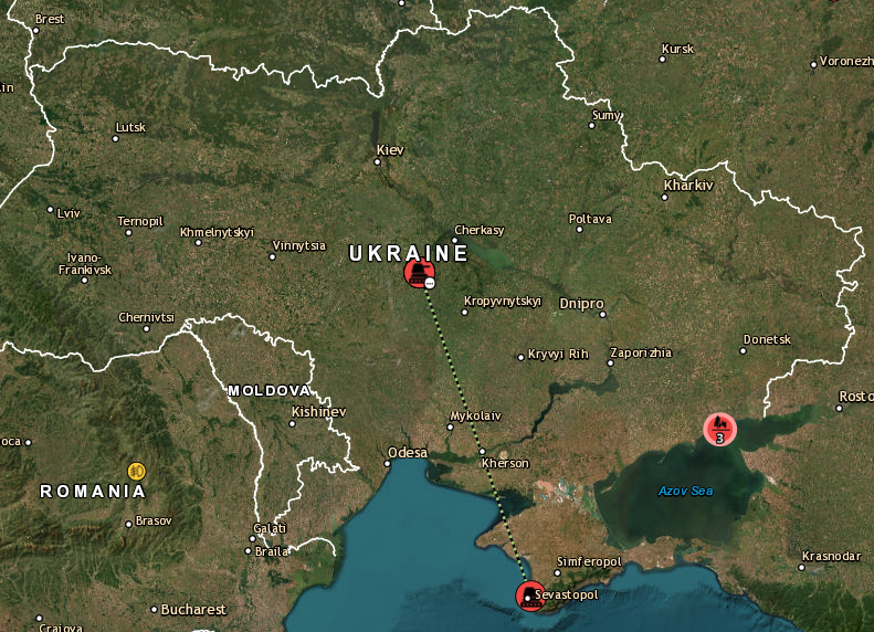
They also give information of what’s happening in Ukraine:
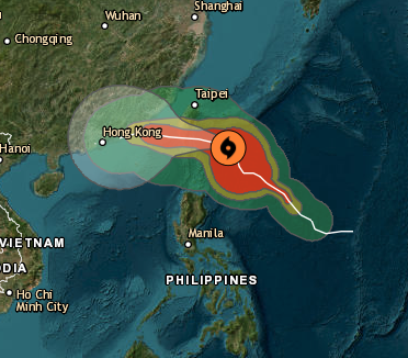
 A tropical cyclone that’s aimed for Hong Kong:
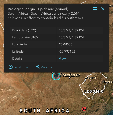
 And bird flu in South Africa:
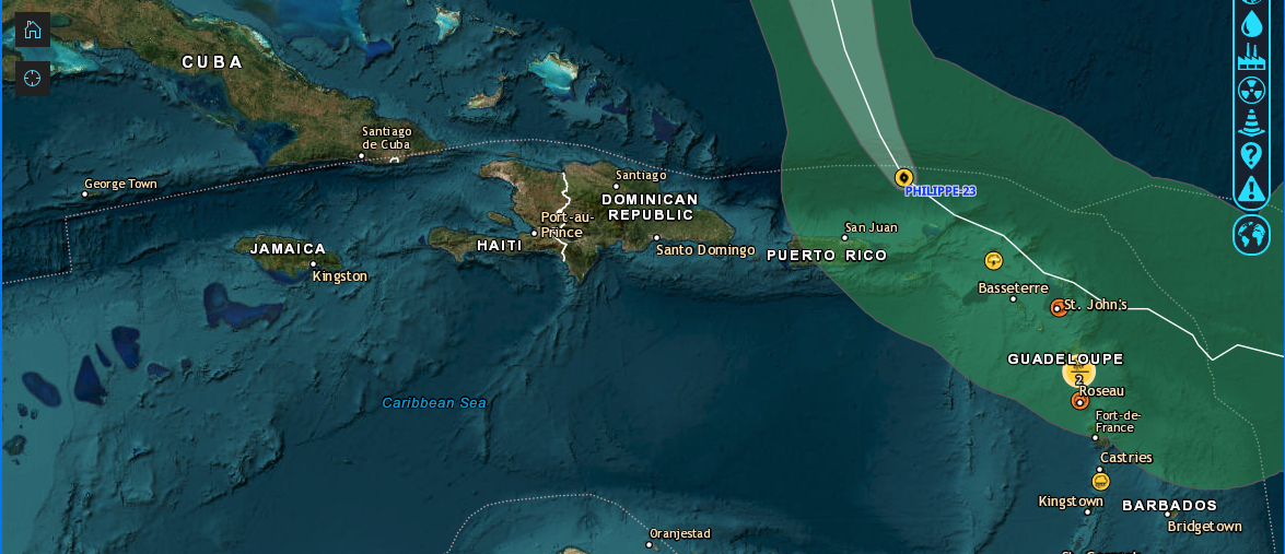
 The map is admittedly not perfect. For all the strife happening in Port-au-Prince, Haiti for example, there’s no mention of the ongoing social-political issues happening there:
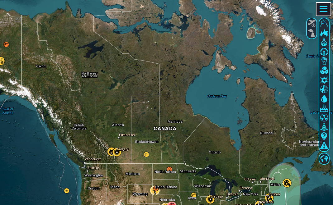
 And for all the wildfires in Canada, they’re not mentioned, either:
 I guess maybe it depends on which sites they’re using to get their information? I don’t know.
But anyway, as a map geek, I found it a pretty interesting site.
You can go directly to the map if you click here.
Want to comment on this post? Great! Read this first to help ensure it gets approved.
Want to sponsor a post, write something for Your Mileage May Vary or put ads on our site? Click here for more info.
Like this post? Please share it! We have plenty more just like it and would love it if you decided to hang around and sign up to get emailed notifications of when we post.
Whether you’ve read our articles before or this is the first time you’re stopping by, we’re really glad you’re here and hope you come back to visit again!
This post first appeared on Your Mileage May Vary
